Friday 10 November 2017

Brooklyn Bridge-Urban Design Masterpiece

Brooklyn Bridge-Urban Design Masterpiece

Brooklyn was founded in the 17th century by Dutch Settlers and was its own city until 1898 when its citizens voted to become a borough of New York. Construction of the famous bridge began in 1869.
John Roebling who thought up the idea of a bridge would never see what he had designed built as he died after crushing his foot in an accident.  The son of John Roebling, Washington Roebling, took the helm after his death but he suffered from the caisson-disease as a result of the works on the pillars of the bridge and was on his deathbed at the time of the bridges inauguration in 1883. On inauguration day 150,000 people eagerly crossed the bridge.

The bridge that spans 1.8 km across the East River, at the time the largest suspension bridge and taller than any building in New York, it set the scene for the skyscraper age that would follow decades later. Gothic in style, it is an iconic piece of engineering, architecture and urban design with its pedestrian walkway in the middle of the two traffic flows. More than just a bridge it is a symbol of New York and its larger than life aura. The bridge demonstrates how good urban design can be a mix of engineering prowess, practicality and beauty.   


Source-http://www.aviewoncities.com/nyc/brooklynbridge.htm
Pictures Source http://www.aviewoncities.com/nyc/brooklynbridge.htm

Thursday 26 October 2017

Walkable Neighborhoods-Economic Implications

Walkability, Economics and the State of Place Index

From a human wellbeing perspective the benefits of walkability have become common knowledge. Walkable neighborhoods produce lower rates of obesity and associated chronic diseases as well as environmental benefits of reduced emissions of greenhouse gases, and improved sustainability and resilience. Now real estate developers have begun to understand these implications and have pushed walkability into the forefront of real estate developments. This is because now 80% of 18-24 year olds want to live in walkable neighborhoods. An AARP survey found that an average of 60% of those over 50 want to live within a mile of daily goods and services.  In 13 of 15 major U.S. markets, an increase of one point in Walk Score ( a way of measuring walkability to commercial destinations on a scale of one to 100) translated into home price premiums of between $700 and $3000.

In New York the city’s Department of Transportation found the following:
  • a series of pedestrian and bicycle infrastructure projects translated into significant returns on investment, with protected bike lanes tied to a 49 percent increase in retail sales, compared with 3 percent boroughwide;
  • small expansions of pedestrian rights-of-way were tied to a 49 percent reduction in commercial vacancies, compared with 5 percent citywide;
  • transformation of an underused parking area translated into a 172 percent increase in retail sales at local businesses over three years; and
  • conversion of a curb lane into outdoor seating increasing pedestrian numbers by more than 75 percent and increased sales at bordering businesses by 14 percent.


Another finding is that mixed use downtown development generates ten times the tax revenue per acre than does sprawl development. It also saves 38 percent on upfront infrastructure costs per unit, and saves 10% on ongoing services delivery.
Maria Alfonzo, who talks about these benefits in her article for the Urban Land Institute has pioneered a new tool she calls the State of Place Index that aims to quantify the economic benefits of Walkability.

Using Houston as an example in the article, the index showed a potential increase in retail sales and tax dollars from improvements for walkability. The index works like this- Firstly neighborhoods are classified within a region according to the types of interventions and investments needed in terms of walkability. Secondly, priorities are set within a neighborhood itself, and types of walkability interventions are indentified, eg, pedestrian amenities, traffic safety, parks and public spaces. These are ranked as to which will give cities and investors the biggest impact for the least cost.
Finally, specific interventions and/or development projects are identified that would have the biggest impact on the State of Place Index. A predicted return on investment is calculated. This tool goes someway to identifying winning strategies that any city can begin to implement and gives a framework in which cities can start to understand where in their own neighborhoods walkability interventions/investments can be made successfully.

https://urbanland.uli.org/sustainability/houston-economic-case-walkability/
All images and text are found at uli.org
Stateofplace.org

Tuesday 24 October 2017

Community Led Urban Design

Community Led Urban Design in San Francisco


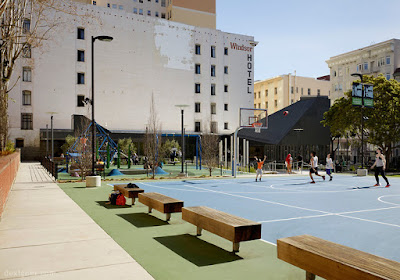
San Francisco's Tenderloin neighborhood is the latest and best example of a neighborhood participating in deigning its open spaces. The idea being that parks are best designed by the community that surround them is not new but is seldom done with success and continuity. To do this the community needed to be engaged with thoroughly.

In this case it is Boeddeker Park, redesigned in 1985, it never lived up to its potential as the neighborhood's largest public park. The Tenderloin neighborhood is the densest in San Francisco and with its accompanying poverty named the park 'Prison park'. Because of its reputation and the need for better public space for residents The Trust for Public Land, in partnership with the City of San Francisco's Recreation and Parks Department, teamed with WRNS Studio to redesign and completely rebuild the site.

Much in the way skyscrapers were built under the 'Build it and they will come' philosophy, the Urban Design equivalent seems to be 'hold a symposium and they will turn up'


A new clubhouse was proposed to meet the needs of the community. The idea of a clubhouse builds on the San Fran tradition of having local clubhouses and is designed to be a living room for the local community, an edgy offset piece of architecture to compliment and contrast with the new park. These ideas came directly from the community outreach meetings. The forums and meetings were held at local youth clubs, civic halls and other community buildings nearby with key decisions made at these forums.


Source Ref-  https://www.dexigner.com/news/30400
All pictures from dexigner taken by Matt Millman.

Monday 23 October 2017

Flood Proof Urban Design

Brisbane Gets Serious about Flood Proof Design.


The worlds first flood proof Ferry terminal has just been awarded the Good Design of the year Award 2017 in Australia. The set of ferry terminals in Brisbane by Aurecon and Cox Rayner Architects (now Cox Architecture) with landscape architecture by Lat27 has been turning heads for its contemporary angular design features. In 2011 the existing ferry terminal was destroyed by tidal surges but the new pontoon can survive a freak weather event (every 500 years), accommodating the rivers tidal range of 2 metres. The design is the product of a design competition instigated by the Queensland government after the tidal surge of 2011.

The new ferry terminal is infact a series of 8 terminals all connected by landscape architecture that any riverside city would be proud of, using local plant species and incorporating green transport routes for walkers, joggers, and cyclists.

The judges were also impressed with the level of collaboration within the multidisciplinary team that included architects, engineers, and landscape architects. They were also excited by its potential to be replicated globally which could save lives and potential costly damage during freak weather events at smaller Ferry Terminals such as the one at Brisbane. Perhaps even larger terminal could learn from its technology too.  


Brisbane Ferry Terminals designed by Aurecon and Cox Rayner Architects (now Cox Architecture), landscape architecture by Lat27. Images courtesy of Landscape Australia taken by Christopher Frederick Jones


Friday 29 September 2017

NYC Hudson Yards- Urban Design Goes Supersize

Hudson Yards is willing multi-use Urban Design into Reality in NYC.

When we think of New York city great buildings and iconic streetscapes spring to mind readily, the flat iron building, central park, the highline to name a couple. So what is happening currently in New York in terms of Urban Design. Well, look no further than a new development in the Hudson Yards. It is to be the single 'largest private real estate development in US history'. That being the case it is as relevant as any planners ideas of how NYC should evolve and is a contemporary snap shot of what urban design means to development, at least in the US.


The development will include 4000 homes, a 200 room hotel, and 14 acres of public spaces such as public gardens and squares as well as copious amounts of cutting edge architecture courtesy of architects such as Diller Scofidio + Renfo in collaboration with Rockwell Group.
The first half of the project, the eastern Hudson Yards, is due to be completed in 2018 completion, then it will be the western Hudson Yards due to be finished and leased by 2025 with a completion date of 2025. Unlike older developments that focussed on single uses such as the Rockefeller Center and Times Square, Hudson Yards is more about blending a number of things at once, namely- commercial, retail, public space, and residential.


According to Jay Cross, President of Related Hudson Yards, the development 'will be the new center of New York'. With 5 million workers living within a 40-minute of commute of Hudson Yards its easy to see why he is so enthusiastic 'We will be the new center of New York, the new heart of New York, but we'll be known for a little of everything and all of everything," Having many uses rolled into one development will give it its dynamism and according to Cross. 'Every New Yorker will have a reason to go to Hudson Yards, and every New Yorker will love Hudson Yards. That's got to be the goal.'
Whether we share Cross's enthusiasm or not, this development will in time give urban designers new data on multiuse developments and their success. Time will tell, I cant wait to see it completed.

Content source- http://www.hudsonyardsnewyork.com/press-media/
Images courtesy of inc.com https://www.inc.com/jeremy-goldman/why-hudson-yards-is-the-future-of-new-york-city.html


Diller Scofidio's design work

Wednesday 18 January 2017

Frederick Law Olmsted-The Landscape Architect Extraordinaire

Born in Hartford Connecticut in 1822, Frederick Law Olmsted had early health problems due to being poisoned by a somac plant which prevernted him from attending Yale. He became a seaman and a prominent journalist amongst other things before dedicating himself to design. In 1848 he bought a 125 acre farm on Staten Island which encouraged him ten years later to enter a competition to design New York's Central Park which he won, being chosen by Calvert Vaux, an English Architect who admired Olmsted's ideas.

A Painting of Frederick Law Olmsted

Olmsted's ideas are still to be seen in Central Park and of course in all the parks that he designed after that, that is that parks are for the public. Green Spaces are to be enjoyed by everybody and not to be gated off for the rich. An interesting thing to note is that it is commonly agreed that Olmsted's inspiration for Central Park came on his visit to Birkenhead Park in Liverpool, England. If you look, the two designs are very similar, going to show that even the best designers need and use inspiration from other designers and the world around them.

Boston's Emerald Necklace Park-A popular approach to park design to this day.


Other notable examples of his work include Golden Gate Park, San Francisco, Boston's Emerald Necklace Park and Belle Isle park New York. Olmsted was an early champion of the conservation movement that is now a key part for global thinking on the environment, and was crucial in helping found the American Society of Landscape Architects in 1898.

Birkenhead Park near Liverpool, England- A source of inspiration for Central Park New York

Saturday 14 January 2017

Leon Battista Alberti

Leon Battista Alberti- Renaissance Master


Born in Genoa in 1404, Alberti was the son of a wealthy Florentine father who's impact on design is unquantifiable. Joining the Papal court as a young man he became interested in ancient ruins which sparked off his love affair with architecture and design. He was also athletic and well read. He in fact wrote a play that was so good it was passed off as classical literature to audiences. He wrote books on painting, and in 1438 was given his first architectural commission, a triumphal arch to support a statue. From this small start he worked his way into the role of architectural advisor to Pope Nicholas V.

Pallazo Rucellai-Florence-An Urban Design Blueprint


His Rucellai Palace of 1486 was his first proper commission and one that would influence western architecture and urban design for 500 years. In 1452 he completed his 'Treatise on Architecture' inspired by the work of Vitruvius, the book is still on the reading list of every Architecture course in the world. His church of Santa Maria Novella is the inspiration for countless churches that followed with its classical scrolls that bridge the nave with the lower aisles.

Santa Maria Novella Church- Inspiration for countless churches since


Alberti was also an avid artist in the humanist tradition. His life's accomplishments cover a vast array of disciplines from cryptography, poetry, prose, sculpture and philosophy. Like the other renaissance masters of his day he was a leading light in a world coming to grips with science and the changing world view of an increasingly intellectually informed populace. To say Alberti did his time justice is an understatement, he helped define it, and his work still resonates with architects, designers and urban planners as contextual, elegant and beautiful. His work bridged the ancient world of privilege and palaces with the increasingly modern world of city streets and merchant houses. He designed the houses and helped the merchants fill them with his books and paintings and helped define what urban design is today. The true Renaissance Master.

Ref- https://en.wikipedia.org/wiki/Leon_Battista_Alberti